Information on Service 'CARS image cutouts'
![[Use this service from your browser]](/static/img/usesvcbutton.png)
Further access options are discussed below
Images and data from from the CFHTLS archive research survey, a
multi-band dataset spanning 37 square degrees of sky in high galactic
latitudes.
For a list of all services and tables belonging to this service's
resource, see Information on resource 'CARS survey data'
Service Documentation
These services deliver products from the CFHTLS-Archive-Research Survey
(CARS). The survey currently offers derived products from 37
sq. degrees of the Wide part from the Canada-France-Hawaii Telescope
Legacy Survey (CFHTLS). The main documentation for the products, its
creation and its content is the publication 2009A&A...493.1197E.
Here, we discuss some points which are not evident from this publication.
AVAILABLE DATA PRODUCTS
For each 1 sq. deg. CARS pointing we currently offer the following products
(we discuss them on the example of the CARS pointing W1m0p1); a typical file
is named W1m0p1_izrgu.V1.7A.final.cat. The name contains the following
information:
- W1m0p1 -- name of CARS field under consideration
- izrgu -- filters involved in the product (here i', r', z', g', u*);
for catalogues etc. the first listed filter corresponds to
the object detection filter (here 'i'; see also 2009A&A...493.1197E)
- V1.7A -- internal CARS version number
- final -- 'final' product
The individual files we offer are:
- W1m0p1_izrgu.V1.7A.final.cat
- object catalogue in FITS binary format; beware that they are very
big and cumbersome to handle if you do not have efficient tools to
work on big FITS binary tables! (typical file size per field: 0.5GB!)
- W1m0p1_izrgu.V1.7A.final.asc.gz
- An ASCII version of W1m0p1_izrgu.V1.7A.final.cat containing a subset
of the most important catalogue quantities. This catalogue should be
sufficient for most users. The main content of the catalogue can
also be queried in the cat service.
(typical gzipped file size per field: 20MB)
- W1m0p1_izrgu.V1.7A.final.reg.gz
An ASCII ds9 region file containing saoimage/ds9 polygon entries
(in pixel coordinates). They represent the CARS image masks described
in Sect. 3.4 of 2009A&A...493.1197E. Polygons originating from different
masking procedures are encoded with different colours (look at
expressions such as '# color=yellow' at the end of each line).
We offer this file so that interested users can construct own masks
containing only parts of our global MASK key. (typical gzipped file size
per field: 1MB)
The colour coding in these files is as follows:
- yellow: masks from our object density analysis and stars identified
in the USNO-A2 catalogue
- green: stars identified in the GSC1 and GSC2 cataogues
- magenta: masks around extended haloes of bright stars
- red: masks from our asteroid track analysis
W1m0p1_irg.V1.7A.truecol.jpg
low resolution true colour i', r' and g' JPG image of the CARS field.
These images allow a quick look at the data but they are probably not
suitable for high-quality poster print-outs. (typical file size per field:
10MB)
- W1m0p1_izrgu.V1.7A.masks.obj.jpg
low resolution JPG image showing object positions and object masks
overlayed on the i'-band image. It allows a quick-look at field-layout
and object positions. (typical file size per field: 3MB)
The colour coding in this is:
- green: areas excluded from scientific analysis by our MASK key
- yellow: stellar sources (SExtractor CLASS_STAR >=0.95)
- red: galaxies with high-confidence photo-z estimates:
(SExtractor CLASS_STAR < 0.95; reliable object photometry
in five bands; BPZ ODDS quality parameter > 0.9);
see also Sect. 4 of 2009A&A...493.1197E
- blue: all other galaxies (SExtractor CLASS_STAR < 0.95)
CATALOGUE QUANTITIES
See 2009A&A...493.1197E, in particular Sect. 4, and the SExtractor Users manual
for a description of most catalogue entries. Also see the table notes.
CURRENT COVERAGE
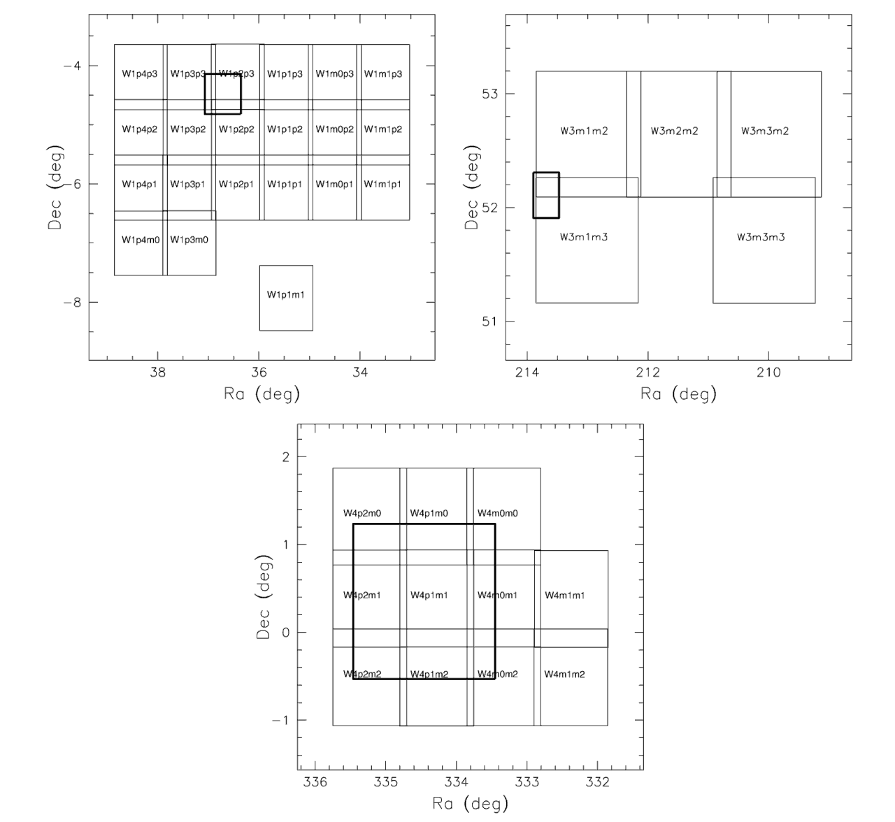
Overview
You can access this service using:
-
form --
an interface for web browsers through an HTML form
-
siap.xml --
a standard SIAP interface as defined by the IVOA to access collections of celestial images; SIAP clients use http://dc.g-vo.org/cars/q/cutout/siap.xml? to access the service
Coverage

Intervals of messenger energies reflected in this resource: 1.0332 3.7571 eV
This service is published as follows:
- Within the
set(s) ivo_managed with the renderer
dali
- Within the
set(s) local,ivo_managed with the renderer
form
- Within the
set(s) ivo_managed with the renderer
siap.xml
local means it is listed on our front page,
ivo_managed means
it has a record in the VO registry.
Other services provided on the underlying data
include:
Default Output Fields
The following fields are contained in the output by default. More
fields may be available for selection; these would be given below
in the VOTable output fields.
| Name | Table Head |
Description | Unit | UCD |
|---|
| accref |
Product key |
Access key for the data
|
N/A |
meta.ref.url |
| accsize |
File size |
Size of the data in bytes
|
byte |
VOX:Image_FileSize |
| bandpassHi |
Band upper |
Upper limit of the bandpass (in BandPass_Unit units)
|
m |
instr.bandpass;stat.max |
| bandpassId |
Bandpass |
Free-form name of the bandpass used
|
N/A |
instr.bandpass |
| bandpassLo |
Band lower |
Lower limit of the bandpass (in BandPass_Unit units)
|
m |
instr.bandpass;stat.min |
| bandpassRefval |
Band Ref. |
Characteristic quantity for the bandpass of the image
|
m |
instr.bandpass;stat.median |
| bandpassUnit |
Bandpass unit |
Unit of bandpass specifications (always m).
|
N/A |
N/A |
| centerAlpha |
Ctr. RA |
Approximate center of image, RA
|
deg |
pos.eq.ra |
| centerDelta |
Ctr. Dec |
Approximate center of image, Dec
|
deg |
pos.eq.dec |
| coverage |
Coverage |
Field covered by the image
|
deg |
N/A |
| dateObs |
Obs. date |
Epoch at midpoint of observation
|
d |
time;obs.exposure |
| fieldBandKey |
Field/Band |
CARS field designation plus band
|
N/A |
meta.id |
| fieldKey |
Field |
CARS field designation
|
N/A |
meta.id |
| imageTitle |
Title |
Synthetic name of the image
|
N/A |
meta.title |
| instId |
Instrument |
Identifier of the originating instrument
|
N/A |
meta.id;instr |
| magzperr |
Err. Mag. ZP |
Estimated Magnitude Zeropoint Error
|
mag |
stat.error;phot.mag;arith.zp |
| mime |
Type |
MIME type of the file served
|
N/A |
meta.code.mime |
| nAxes |
#axes |
Number of axes in data
|
N/A |
pos.wcs.naxes |
| ncombine |
Combined |
Number of individual frames in this stack
|
N/A |
meta.number |
| pixelScale |
Scales |
The pixel scale on each image axis
|
deg/pixel |
pos.wcs.scale |
| pixelSize |
Axes Lengths |
Number of pixels along each of the axes
|
pixel |
pos.wcs.naxis |
| pixflags |
P. Flags |
Flags specifying the processing done (C-original; F-resampled; Z-fluxes valid; X-not resampled; V-for display only
|
N/A |
meta.code |
| refFrame |
Ref. Frame |
Coordinate system reference frame
|
N/A |
pos.frame |
| seeing |
Seeing |
Measured image seeing
|
arcsec |
instr.obsty.seeing |
| texptime |
Tot. Exposure |
Total Exposure Time
|
s |
time.duration;obs.exposure |
| wcs_cdmatrix |
CD matrix |
FITS WCS CDij matrix
|
deg/pixel |
pos.wcs.cdmatrix |
| wcs_equinox |
Equinox |
Equinox of the given coordinates
|
yr |
time.equinox |
| wcs_projection |
Proj. |
FITS WCS projection type
|
N/A |
pos.wcs.ctype |
| wcs_refPixel |
Ref. pixel |
WCS reference pixel
|
pixel |
pos.wcs.crpix |
| wcs_refValues |
Ref. values |
World coordinates at WCS reference pixel
|
deg |
pos.wcs.crval |
VOTable Output Fields
The following fields are available in VOTable output. The verbosity
level is a number intended to represent the relative importance
of the field on a scale of 1 to 30. The services take a VERB argument.
A field is included in the output if their verbosity level is
less or equal VERB*10.
| Name | Table Head |
Description | Unit | UCD |
Verb. Level |
|---|
| centerAlpha |
Ctr. RA |
Approximate center of image, RA
|
deg |
pos.eq.ra |
0 |
| centerDelta |
Ctr. Dec |
Approximate center of image, Dec
|
deg |
pos.eq.dec |
0 |
| imageTitle |
Title |
Synthetic name of the image
|
N/A |
meta.title |
0 |
| dateObs |
Obs. date |
Epoch at midpoint of observation
|
d |
time;obs.exposure |
0 |
| accref |
Product key |
Access key for the data
|
N/A |
meta.ref.url |
1 |
| bandpassId |
Bandpass |
Free-form name of the bandpass used
|
N/A |
instr.bandpass |
10 |
| accsize |
File size |
Size of the data in bytes
|
byte |
VOX:Image_FileSize |
11 |
| pixelScale |
Scales |
The pixel scale on each image axis
|
deg/pixel |
pos.wcs.scale |
12 |
| instId |
Instrument |
Identifier of the originating instrument
|
N/A |
meta.id;instr |
15 |
| pixelSize |
Axes Lengths |
Number of pixels along each of the axes
|
pixel |
pos.wcs.naxis |
15 |
| ncombine |
Combined |
Number of individual frames in this stack
|
N/A |
meta.number |
15 |
| texptime |
Tot. Exposure |
Total Exposure Time
|
s |
time.duration;obs.exposure |
15 |
| mime |
Type |
MIME type of the file served
|
N/A |
meta.code.mime |
20 |
| nAxes |
#axes |
Number of axes in data
|
N/A |
pos.wcs.naxes |
20 |
| refFrame |
Ref. Frame |
Coordinate system reference frame
|
N/A |
pos.frame |
20 |
| wcs_equinox |
Equinox |
Equinox of the given coordinates
|
yr |
time.equinox |
20 |
| wcs_projection |
Proj. |
FITS WCS projection type
|
N/A |
pos.wcs.ctype |
20 |
| wcs_refPixel |
Ref. pixel |
WCS reference pixel
|
pixel |
pos.wcs.crpix |
20 |
| wcs_refValues |
Ref. values |
World coordinates at WCS reference pixel
|
deg |
pos.wcs.crval |
20 |
| wcs_cdmatrix |
CD matrix |
FITS WCS CDij matrix
|
deg/pixel |
pos.wcs.cdmatrix |
20 |
| bandpassUnit |
Bandpass unit |
Unit of bandpass specifications (always m).
|
N/A |
N/A |
20 |
| bandpassRefval |
Band Ref. |
Characteristic quantity for the bandpass of the image
|
m |
instr.bandpass;stat.median |
20 |
| bandpassHi |
Band upper |
Upper limit of the bandpass (in BandPass_Unit units)
|
m |
instr.bandpass;stat.max |
20 |
| bandpassLo |
Band lower |
Lower limit of the bandpass (in BandPass_Unit units)
|
m |
instr.bandpass;stat.min |
20 |
| pixflags |
P. Flags |
Flags specifying the processing done (C-original; F-resampled; Z-fluxes valid; X-not resampled; V-for display only
|
N/A |
meta.code |
20 |
| coverage |
Coverage |
Field covered by the image
|
deg |
N/A |
20 |
| fieldKey |
Field |
CARS field designation
|
N/A |
meta.id |
20 |
| fieldBandKey |
Field/Band |
CARS field designation plus band
|
N/A |
meta.id |
20 |
| magzperr |
Err. Mag. ZP |
Estimated Magnitude Zeropoint Error
|
mag |
stat.error;phot.mag;arith.zp |
20 |
| seeing |
Seeing |
Measured image seeing
|
arcsec |
instr.obsty.seeing |
20 |
| owner |
Owner |
Owner of the data
|
N/A |
N/A |
25 |
| embargo |
Embargo ends |
Date the data will become/became public
|
yr |
N/A |
25 |
| magzp |
Mag. ZP |
AB Magnitude Zeropoint
|
mag |
phot.mag;arith.zp |
25 |
| seeingerr |
Err. Seeing |
Measured image Seeing error
|
arcsec |
stat.error;instr.obsty.seeing |
25 |
Copyright, License, Acknowledgements
If you use the CARS products for your own research,
please give proper acknowledgment to
CADC, the
CFHTLS project and the
publication 2009A&A...493.1197E
Citation Info
VOResource XML (that's something exclusively for VO nerds)